Gannett Peak
Overview
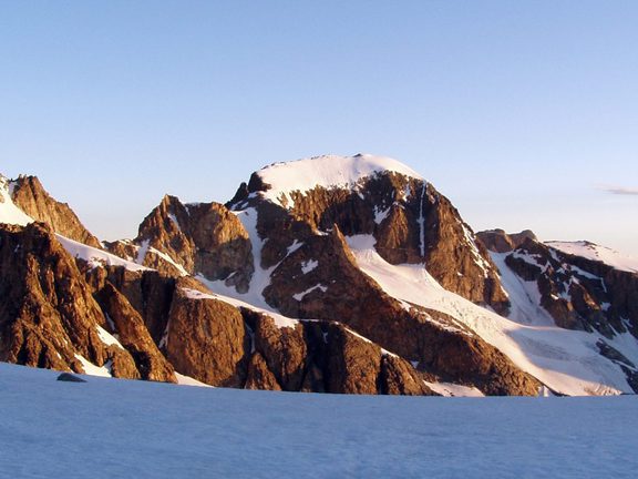
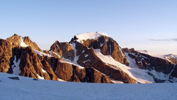
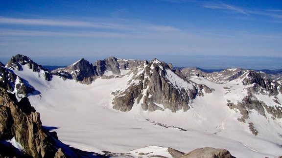
Gannett Peak is remotely located in the northern Wind River Mountain Range, situated on the Continental Divide National Scenic Trail in both the Fitzpatrick and Bridger Wilderness Areas. A formidable mountain in itself, Gannett Peak is only accessed after enduring hikes at high altitudes and mountain passes, glacier and rock travel, and finicky, potentially dangerous, weather patterns. The 896 acre Gannett Glacier is the largest single glacier in the American Rocky Mountains.
Popular Activities
WYOMING’S HIGHEST MOUNTAIN
AT 13,804 FEET
Gannett Peak is thought amongst mountaineers to be one of the most difficult state high-point summits in the nation, and climbing it is one of America’s premier wilderness mountaineering trips.
CAMPING NEAR GANNETT PEAK
There are no suitable camping areas on the peak itself, so be prepared for a long day in and out (20-hour day) hiking part of the trip on snow and glaciers. It is NOT recommended or safe to camp on glaciers, so suitable basecamps are approximately 3000’ below the peak summit. Gannett is the longest round trip approach of any state high-point in the nation.
Campsite locations are rather sparse near Titcomb Basin, and privacy is minimal due to the alpine setting. Bears are plentiful in this area and campers are required to keep a clean camp and store food away from bears and other animals. Bear-proof portable food storage containers are available for loan at the Pinedale Ranger District and the Great Outdoor Shop in Pinedale for a small fee.
CLIMBING GANNETT PEAK
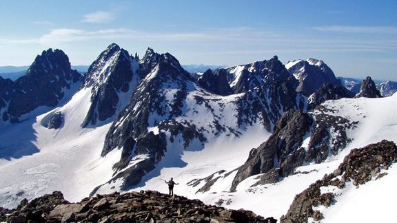
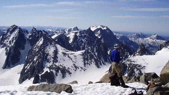
Gannett Peak is accessible from several routes. From Elkhart Park trailhead near Pinedale, the route of approach usually goes past Seneca and Island Lakes to the head of the Titcomb Basin. Depending on the overall length of the trip, training requirements, and whether horse packers have been used or not, it will take you 1 to 4 days to reach the upper Titcomb Lake. Weather, conditioning, timing, and other variables may determine the exact location of the summit camp. Start early on summit day to reach the top in the morning hours before storms move in and return to camp before dark. The most popular route up Gannett is Gooseneck Glacier.
All approaches are technical and entail crossing glaciers, snow climbing, and rock scrambling. Approaches from the Green River Lakes or New Fork Lake trailheads on the west side of the Wind River Range are longer than the traditional approach routes but provide more solitude. Access to Gannett Peak is also possible from the Dubois side, with the Glacier Trail being the main and most popular trail. If accessing Gannett via the more scenic Titcomb Basin, expect to see other backpackers, climbers, and folks with livestock.
It is important to plan for additional time to become acclimated to the high elevation, to be physically fit for the strenuous hike and climb, and knowledgeable about equipment and techniques for safety. Typical conditions on Gannett Peak require a boot sturdy enough for glacier crampons and stiff enough for snow climbing. Plastic mountaineering boots are not necessary; a mid-weight leather or waterproof fabric boot is adequate. Ice axes and crampons should be of good quality and the correct size, and each party member should be aware of how to safely use them, including in a self-arrest situation. Most people rope up.
It is common for summit parties to plan a week for the approach to Gannett, the ascent, and delays due to bad weather days. Be prepared for drastic, unexpected weather conditions, including snowfall any day of the year. Summer days typically come with afternoon thunderstorms and dangerous lightning. Before heading out, get current trail conditions and advisories for the area. The hike is over 45 miles roundtrip and an almost 9,000-foot vertical climb. The best climbing months are late June, July, August, and early September. Conditions vary from season to season, so check ahead of time to know what to expect. Novices and newcomers are advised to hire guides to lead them through any trip.
CONDITION OF GLACIERS
Over the past years, climbers report that the Gooseneck Route has changed dramatically due to receding and melting glaciers. The bergschrund is also becoming a more complex obstacle to overcome. It is recommended that groups attempting to climb this peak go early in the season so that snow bridges are in better condition for traveling. Check on conditions regularly, as snowfall can be inconsistent from season to season.
LOCATION
Gannett Peak is most often approached Elkhart Park Trailhead out of Pinedale or from the north via Dubois, WY.
LOGISTICS
GLACIERS
Gannett Peak has five rugged glaciers on its flank, the largest glaciers in the American Rocky Mountains. It is remote and considered an alpine mountaineering challenge due to its inaccessibility and difficulty. The mountain was first climbed in 1922.
EXPERIENCE
This trip is best tackled by strong and experienced climbers with great stamina, who are well-acclimated to high elevations. The trip includes traversing glaciers that contain deep crevasses that can lay hidden under a coat of shallow snow. Ropes, crampons, ice axes, and both knowledge and understanding of proper usage are essential. Furthermore, the strenuous 20+ mile trail approach adds to the endeavor.