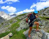
Several local companies provide shuttle transportation to some trailheads by prior arrangement. Guided hiking expeditions, horseback trips, and llama rentals (for those who prefer not to pack their own gear) are available through local outfitters and guides.
Hiking the Wind River Range
The western slopes of the Wind River Range can be accessed at ten trailheads throughout the hundred-mile long range and are most popular during July and August. The different trails within these areas range from short, easy day hikes to extended backpacking trips. Major trailheads into the Wind River Mountains are located at Green River Lakes, New Fork Lakes, Willow Creek Guard Station, Spring Creek Park, Elkhart Park, Boulder Lake, Scab Creek, and Big Sandy. Lower-use trailheads are accessed at Burnt Lake, Meadow Lake, Half Moon Lake, Union Pass, Sweetwater Gap and Little Sandy. All roads to the trailheads (except to Elkhart Park) are unpaved.
The Continental Divide National Scenic Trail (CDNST) traverses many miles along the Bridger-Teton National Forest within the range, winding from South Pass to Union Pass as part of the trail system that extends from Canada to Mexico. This remote trail, which includes the renowned Cirque of the Towers, offers some of the most spectacular scenery and challenging hiking within the Wind River Mountains and Bridger Wilderness. It is highly recommended to check out these great books and maps to plan your hiking adventure.
Hiking the Wyoming Range
The Wyoming Range, located in the western part of the state, runs north to south for nearly 80 miles, with its highest point reaching 11,363 feet. Because these mountains are not as publicized as the Wind River Range, it is a great place to find solitude and an outdoor experience away from the crowds.
Out of the many backcountry hiking trails within these mountains, included is the Wyoming Range National Recreation Trail. The 75 mile long Wyoming Range National Recreation Trail (WRNRT) follows the crest of the Wyoming Range, peaking out at 10,500 feet, on Wyoming Peak. Difficulty varies from moderately easy to difficult, as there are short, steep sections where the trail is poorly marked and indistinct. Much of the trail is above 9,000 feet in elevation. The trail heading to Wahelo Falls begins at Middle Piney Lake, and provides access to the trail and Wyoming Peak, for a panoramic view.
The entire trail is open to hikers, horseback riders and mountain bikers. One section, from Lake Creek to North Piney Creek is open to motorcycles/ trail bikes.
Wildlife include elk, moose, deer, black bear and grizzly bear.
The Wyoming Range National Recreation Trail may be accessed as early as mid-May and as late as mid-October, however optimum trail conditions occur in August and September.
Hiking Access & Typical Conditions
Trails are most accessible from July to September, and snow is usually absent from July until October. Due to the high elevation of these mountain ranges, caution for altitude sickness is advised when hiking. Trailheads are as much as 40 miles from the nearest town. Cell phone service is weak to non-existent and no telephones are available at the trailheads. Hikers and backpackers are advised to carry a map, compass, extra clothing, food, mosquito repellent/face nets, bear spray, and water, as well as a form of water purification for extended trips as there is a risk of giardia contamination from the mountain water.
- Practice good campfire safety and make sure the fire is completely out before leaving your camping site.
- Be familiar with food storage requirements when camping
- Organized Groups and Recreational Livestock Users are required to have a Bridger Wilderness Permit


