Hiking & Backpacking Near Pinedale, WY
Page Summary: Hiking & Backpacking Guide to Sublette County, WY. Hundreds of miles of hiking & backpacking in the Wilderness & NF.
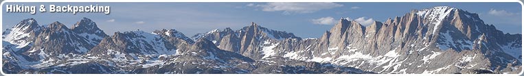
 Hiking & Backpacking in the Wind River, Gros Ventre, & Wyoming Mountain Ranges
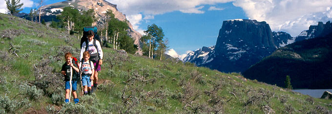
There are hundreds of miles of hiking and backpacking trails available around Pinedale, Wyoming for outdoor recreationists that traverse a wide variety of terrain from the highest rims along the Continental Divide to open sagebrush valleys. Some trails receive high use and extend for many miles, while others offer short hikes to scenic locations that receive low use and minimal impact from other users. Trail systems are extensive in the Wind River Mountain Range and Jim Bridger Wilderness, the Gros Ventre Wilderness Area, and in the Wyoming Range. Trailheads to remote areas can be accessed by vehicle during the summer months, and often are located near campgrounds. Some trailheads have corrals and parking areas for horses and trailers, others are primitive and road access is rough. The high country typically opens up around mid-July and remains open through mid-September. Snow can occur at any time, however, and visitors should be prepared for the possibility of subfreezing temperatures even in the summer. Afternoon thunderstorms, with lightning and rain showers, are common during the summer. Typical daytime summer temperatures in the high country reach the 70s-80s with nighttime lows averaging in the 30s.
Wind River Range Hiking and Backpacking
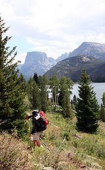
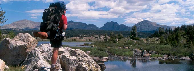
The western slopes of the Wind River Range can be accessed by ten trailheads at various locations throughout the hundred-mile long range. Peak use for trails is during July and August. Some areas, especially in the Bridger Wilderness of the Wind River Range, receive very high use and visitors can expect to share these trails with many other hikers. Other areas, especially in the Gros Ventre and Wyoming Range, receive much less use and visitors may enjoy long hikes, or even days, without seeing another hiker on the trail with them. There are a wide variety of hiking opportunities available from short, easy day hikes for inexperienced hikers to extended backpacking trips into the remote backcountry for the more veteran hikers. Many local Outfitters & Guides provide guided hiking expeditions into the backcountry or horseback riding trips for those who prefer not to walk the trip themselves. Some outfits also offer llama rentals for those who would prefer not to pack their own gear into the backcountry. Several local companies provide shuttle transportation to trailheads and pickup services by prior arrangement.
Major trailheads into the Wind River Mountains are located at Green River Lakes, New Fork Lakes, Willow Creek Guard Station, Spring Creek Park, Elkhart Park, Boulder Lake, Scab Creek, and Big Sandy. In addition, there are lower use trailheads at Burnt Lake, Meadow Lake, Half Moon Lake, Union Pass, Sweetwater Gap and Little Sandy. All roads to trailheads, except Elkhart Park, are rough and unpaved, but passable for passenger cars. Some trailheads are as much as 40 miles from the nearest town, so be sure to have a full tank of gas, good tires, plus at least one spare, and bring extra clothing food, and water. There are no telephones at trailheads and cell phone reception is very spotty. Be aware that trails may not be well marked in some places or may be unmaintained. Be sure to bring a good hiking map and a compass, and a good guide book is also recommended.
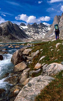
The Continental Divide Scenic Trail traverses many miles along the Bridger-Teton National Forest within Sublette County. This trail winds from South Pass to Union Pass as part of the trail system that extends from Canada to Mexico. This remote trail offers some of the most spectacular scenery and challenging hiking within the Wind River Mountains and Bridger Wilderness area. Services are few and far between along this trail, so careful planning is needed to arrange resupplies at designated points if you plan to do so. Some commercial facilities are located in the area, but none are particularly close to the trail and all require side trips to get to. These rugged mountains are a popular backpacking area for people from around the world. The Cirque of the Towers, in the southern portion of the range, is also a popular backpacking and rock climbing destination in the Wind River Mountains.
Wyoming Range Hiking and Backpacking
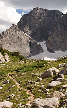
The Wyoming Range is not as rugged or remote as the nearby Wind River Range or Gros Ventre Mountains, but has a striking beauty all its own. The range runs for nearly eighty miles in a north-south direction in western Wyoming. The highest point is Wyoming Peak at 11,363 feet, and many of the peaks in the range rise to over 10,000 feet. Because these mountains are not as publicized as the Wind River Mountains, it is a great place to go to find solitude and an outdoor experience away from the crowds. Many backcountry hiking trails traverse these mountains, including the Wyoming Range National Recreation Trail. Trails are open to hikers, horseback riders and mountain bikers. Trails traverse remote, primitive country, and in some places trails may be hard to find. Roads usually are snow free from mid July until mid October.
The Wyoming Range National Recreation Trail runs for approximately 70 miles along the Wyoming Range, with much of the trail at or near the crest above 9,000 feet elevation. Most of the trail is closed to motorized vehicles, although one short segment between Lake and North Piney creeks is open to trail bikes. The rest of the trail is for hikers, horseback riders and mountain bikers. Access is typically from July through September, although some portions may be accessed as early as mid-May or as late as mid-October, depending on the weather. Best time for optimum trail conditions and access is August and September. The trail begins in the north in the Hoback Canyon at Bryan Flat/Willow Creek at an elevation of 6,300 feet and ends at the South Piney Creek Trailhead at an elevation of 8,200 feet.
Conditions
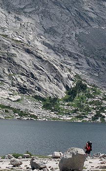
All area hiking trailheads are located at what is considered high elevation, at least 7,000 feet, and many begin at over 9,000 feet in elevation. Remote trails can often traverse several more thousand feet in elevation. For those unaccustomed to high altitude, the danger of altitude sickness is very real and can be deadly. Visitors should familiarize themselves with the symptoms and be watchful of the onset amongst their companions while hiking in the high country. Also, drinking water must either be packed in or water from lakes and streams purified by approved techniques before drinking to avoid being infected with giardia, a parasite that is found in nearly all surface water in the area. The water in the backcountry looks clean and pure, but visitors are advised to purify drinking and cooking water with a filter or purifier, by boiling, or by using iodine tablets.