Wind River Mountains
Page Summary: Discover the Wind River Mountains and Jim Bridger Wilderness Area of Wyoming.
 Wind River Mountains and Jim Bridger Wilderness Area
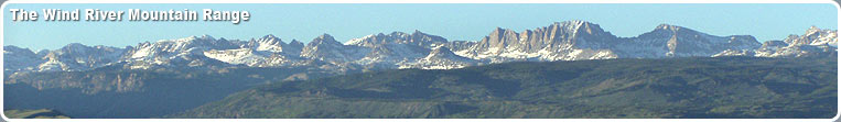
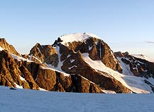
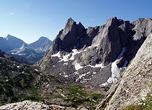
The Wind River Range stretches more than 100 miles in western Wyoming and contains 35 named peaks over 13,000 feet in elevation. Gannett Peak, Wyoming's highest, is in the Wind River Range. Seven of the largest glaciers in the Rocky Mountains are located in the Wind River Range. There are no roads in the wilderness, and mechanized vehicles, including mountain bikes and snowmobiles, are not allowed. The Wind River Range encompasses an area of 2.25 million acres and forms a triple divide for three major western watersheds: the Columbia River, the Colorado River, and the Missouri. The Winds are a mecca for backcountry travelers and offer exceptional backcountry trail trips, mountaineering, technical rock climbing, and wilderness experiences.
The high country typically opens up around mid-July and remains open through mid-September. Snow can occur at any time, however, and visitors should be prepared for the possibility of subfreezing temperatures even in the summer. Afternoon thunderstorms, with lightning and rain showers, are common during the summer. Typical daytime summer temperatures in the high country reach the 70s-80s with nighttime lows averaging in the 30s.
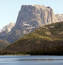
The 428,000-acre Bridger Wilderness area is part of the western slopes of the Wind River Range. It is named after famous mountain man Jim Bridger, who lived in this area during the early 1800s. Most of the Bridger Wilderness lies within Sublette County and is managed by the Pinedale Ranger District of the Bridger-Teton National Forest. The Wind River Range has over 1,300 lakes and hundreds of miles of streams and numerous hiking trails.
Hiking, Backpacking and Rock Climbing
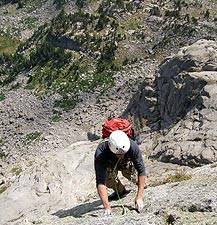
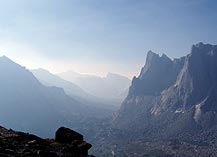
These rugged mountains are a popular backpacking area for people from around the world. The Continental Divide Trail traverses the Winds from South Pass to Union Pass as part of the trail system that extends from Canada to Mexico. The Cirque of the Towers, in the southern portion of the range, is a popular technical rock-climbing destination. See hiking for more information.
Several trailheads provide access to the western Wind River Range and Bridger Wilderness. Major trailheads are located at Green River Lakes, New Fork Lakes, Willow Creek Guard Station, Spring Creek Park, Elkhart Park, Boulder Lake, Scab Creek, and Big Sandy. In addition, there are lower use trailheads at Burnt Lake, Meadow Lake, Half Moon Lake, Union Pass, Sweetwater Gap and Little Sandy. All roads to trailheads, except Elkhart Park, are rough and unpaved, but passable for passenger cars. Some trailheads are as much as 40 miles from the nearest town, so be sure to have a full tank of gas, good tires, plus at least one spare, and bring extra clothing food, and water. There are no telephones at trailheads and cell phone reception is very spotty. Be aware that trails may not be well marked in some places or may be unmaintained. Be sure to bring a good hiking map and a compass, and a good guidebook is also recommended.
Special regulations apply to those using the backcountry, and visitors should check with the local Forest Service office for specifics that apply to their visit. Pets are allowed, but must be kept under control and away from other camps. Registration boxes are provided at all major trailheads, and visitors are asked to register at these stations. Organized groups are required to obtain a free permit from the local Ranger Station office before venturing into the Bridger Wilderness area.
The water in the backcountry looks clean and pure, but visitors are advised to purify the water before drinking it to destroy organisms that can make your very ill. Drinking and cooking water should be treated with a filter or purifier, by boiling, or by using iodine tablets.
Commercial services for pack trips, guided hunts, and guided fishing are provided by licensed guides under Special Use Permits from the Bridger-Teton National Forest. Local District offices can provide a list of qualified, permitted outfitters and guides who can provide fully catered trips, horseback or llama support, and climbing equipment.
Wildlife
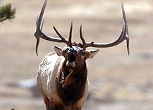
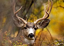
The Winds are home to many species of wildlife including moose, elk, deer, black and grizzly bear, wolves and mountain lions. Many of the high lakes are stocked with fish including Rainbow, Cutthroat, Brook, Golden and Brown trout, as well as Grayling and Mackinaw. Fishermen are required to have a valid Wyoming fishing license and should be familiar with current fishing regulations, which may change each year. Livestock grazing allotments for cattle and sheep are also found in the forest and wilderness areas. See wildlife for more information.
Continental Divide National Scenic Trail
The Continental Divide National Scenic Trail (CDT) runs from Mexico to Canada, and in Wyoming goes from the Sierra Madre mountains to the western edge of Yellowstone National Park along the Continental Divide. Approximately 80 miles of the Trail passes through the Bridger-Teton National Forest from the Big Sandy Opening to Green River Lakes. The Trail reaches an elevation of over 11,000 feet in the Wind River Range and then drops out near Green River Lakes. The higher portion is usually free of snow sometime around mid-July, depending on the weather. August and September are more reliable to have clear trails all along the route. The trail is obscure in places, but is marked with CDT signs, wooden signs, tree blazes or rock cairns. The Trail passes through glacier-carved valleys surrounded by high, snow-capped mountain peaks and lush alpine meadows dotted with wildflowers.
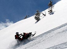
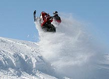
Continental Divide Snowmobile Trail
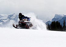
The Continental Divide Snowmobile Trail (CDST) follows the Wind River Range and includes trail systems on both sides of the Continental Divide in Wyoming. The Trail goes through the Lander, Pinedale, Dubois, Togwotee Pass and Gros Ventre areas. It runs from Lander (the southeast end) to West Yellowstone (the northwest end), and generally parallels the Continental Divide, actually crossing it four times. This unique and extensive trail system provides more than 600 miles of continuous riding from south Pass to Yellowstone National Park. The system incorporates private, state, National Forest and Bureau of Land Management lands. Because of the high location on the Continental Divide, sometimes more than 13,000 feet, snow depths range from 5-10 feet. The Continental Divide trail is consistently rated in the top 5 best trails in 12 western states by Snowest magazine readers with the highest marks being given to scenery. Snowmobiling season typically runs from early December through mid April. January through mid-April is generally considered to be the best time. Temperatures at this time of year usually range from lows near zero to daytime highs in the mid twenties. Most days are sunny. The terrain is quite variable, ranging from flat to gently rolling sagebrush prairie to very rugged forested mountains.
The CDST goes right through Pinedale, and the town is a major access point for Trail riders. The trails provide access to the towns of Lander, Dubois and Jackson, as well as to Pinedale, where you can ride your machine directly to lodging and restaurants. The elevation in Pinedale is 7,175', but many trails are over 10,000'. The trail from Irish Canyon Trailhead to Pinedale (approximately 30 miles) is in the highway right-of-way, but even this section is beautiful and fun to ride. Low snow conditions are possible in the Boulder to Pinedale section. It is another 12 miles into Pinedale. The longest stretch between fuel stops is between the Lander trailheads and Boulder(approximately 90 miles). Snowmobiling is allowed in Pinedale with the restriction that you can cross Main Street but cannot ride down the street. From Pinedale north to the upper Green River Trailhead, the CDST is in the highway right-of-way again for about 30 miles. The Pinedale Area trail system has 141 miles of trail through and some of the most scenic country in the West. There are miles of open country with mountains in view everywhere. The snow at higher elevations can be six to eight feet deep. All services are available in Pinedale and gas, food, lodging, rentals and guides are found close to the Upper Green River Trailhead.
The Pinedale Snow Explorers Club schedules many events throughout the winter, and welcomes visitors to the area to participate. In early February, the Snowmobile Winter Drags bring 100s of riders to town and feature high speed exciting racing. During the summer, the Club holds the annual Snowmobile Grass Drags in Pinedale.
Snowmobiling trail maps are available http://wyotrails.state.wy.us/snow/index.asp, and the Sublette County Visitor's Center in downtown Pinedale, and can also be ordered from the State (see contact information below). It is important for snowmobilers to refer to these maps for trail locations and restricted use areas. Restrictions vary by area and may not always be marked on the trail. Snowmobiling is not allowed within National Forest Wilderness Area boundaries.
More Information
Trail Condition Information Phone Numbers:
Weekly snowmobile trail conditions: http://wyotrails.state.wy.us/snow/index.asp
Wyoming tourism information: 307-777-7777
Avalanche Center for Northwestern Wyoming: 307-733-2664
Online Daily Backcountry Avalanche Hazard Web Site
For further information, please contact:
Pinedale Ranger District
29 E. Fremont Lake Road
P.O. Box 220
Pinedale, WY 82941
(307) 367-4326
Avalanche Center for Northwestern Wyoming: 307-733-2664
