New Fork River
Page Summary: The New Fork River is a major tributary of the Green River. It can be floated for most of its length providing great fishing.
 The New Fork River
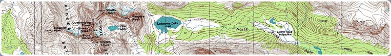
The New Fork River originates at New Fork Lakes, in the arms of the Wind River Mountains 24 miles north of Pinedale. It veers southeast, gathering up the smaller streams that flow down from Wind River drainages: Willow Creek, Pine Creek, Pole Creek, Boulder Creek, and the East Fork River. The New Fork carves a boundary around the northeast and southeast edges of the Mesa before joining the Green River just below State Highway 351, fortifying the Green for its rendezvous with the Colorado and finally the Gulf of California.
Not as big or famous as the Green River, the New Fork has a peaceful and intimate character as it makes its way through grassy meadows, subdivisions, and ranch lands and below sagebrush benches and looming bluffs. Large stands of cottonwood and willow offer shade and attract wildlife. Convenient public boat accesses make this river a heavenly float. Fishermen are rewarded with brook trout, brown trout, rainbow and whitefish. Local commercial guides are also available for float and fishing trips on the New Fork. They are well acquainted with the regulations, the river and the best times and places to be on it.
In Wyoming, fishermen and other recreationists on waters going through private land must remain in their vessels. There is no bank fishing or wading allowed unless permission has been granted by the landowner. On the New Fork River, fences to control livestock rarely cross the river in the summer and early fall, but be alert for bridges, cables, fallen trees, and any objects crossing the water. Consult a good map and know where you are. It is the responsibility of the recreationists to recognize and respect private property.
On public land, anyone may wade, float, or fish from the river's bank, although this is not always safe and some locations may not be appropriate for such activities. Consult Wyoming Game and Fish maps for details on public land sections and easements along the river. Most of the New Fork River's course is a long way from emergency services: use caution and wear a life vest. Because much public land is open to multiple uses, you may find yourself sharing a permitted grazing area with local ranchers' cattle or sheep.
Boat Launches
After it leaves the Bridger-Teton National Forest near New Fork Lakes, the New Fork River passes largely through private land, and is not big enough to float on until it gets close to Pinedale. At that point, public access boat launches provided by the Wyoming Game and Fish Department offer several opportunities for boaters to spend a day floating down different sections of the river. Boaters may park a vehicle and boat trailer or otherwise arrange for pickup at the desired take-out point, then launch from a designated put-in upriver. Be sure to bring extra clothing, food, water, safety and fishing gear, hat, sunblock and insect repellent. There are few opportunities to buy supplies near public river accesses on the New Fork. See the river access map (400K PDF) for suggested boat access points.
Pinedale - Tyler Street
The first public boat launch area is located south of Pinedale on County Road 123. Take Tyler Street south from town. The road will turn to gravel just outside of town, after the water treatment facility. After about a mile and a half, the road crosses a cattle guard and then a bridge over the New Fork. Immediately after the bridge there is a turn-off to the left, and a parking area for the river access. The next put-in or take-out point on the New Fork is near the Pinedale airport, about 4 miles downstream. Contact the Wyoming Game and Fish office in Pinedale for access information.
Boulder Bridge
One of the most popular public access sites on the New Fork is the Boulder Bridge. The road leading from US Highway 191 down to the river just south of the town of Boulder is marked. Parking, the boat launch area, and a public restroom, are located on the south side of the bridge.
Between the Boulder bridge and the bridge at State Highway 351 about 17 road miles south, are two undeveloped access areas. Neither site is well marked. To reach the first site, at the New Fork/East Fork Confluence, head south from Boulder on 191. After a few miles, you will cross the East Fork River. Approximately .9 miles south of the crossing, turn right onto the well-traveled, gravel-surfaced Boulder South Road. After about 1.4 miles, the main road will begin to bend to the left, but you will need to turn right onto a rough two-track road. Two roads actually take off from the main road here, but the one heading northwest (a hard right) will take you to the river. You will go through a cattle guard before dropping down a hill to the river, a distance of about .4 miles. There is no developed boat ramp, but small boats can be launched from this site.
Gas Wells
The next site down river is called the Gas Wells access. From US Highway 191, turn off on the Boulder South Road as you would for the previous access. Continue down this gravel road for about 4.5 miles. Turn right onto another gravel road. There are several old two-track roads that take off from the main road, but you will need to take the one that looks like it heads straight to the river. If you go past an old corral or some large tanks, you have gone too far. There are no developed facilities at this site, but the bank of the river has a gentle slope that will allow you to easily launch or take out a small boat.
Piney Cutoff
To reach the next public access point, continue along the Boulder South Road to State Highway 351. Turn right (west) and proceed less than a mile to where the New Fork River crosses the highway. By this bridge is the Piney Cutoff access. This popular boat launch site and developed picnic area has tables and toilets provided by the BLM. The area was popular long before the BLM was invented, in fact. About a mile north, the Oregon Trail crosses the New Fork River, and it is easy to imagine dusty pioneers shouting for joy at the sight of tall cottonwoods and the sound of running water, after a long wagon ride over the sunbaked sagebrush steppe. The Piney Cutoff is a good place to start a day-long float to the Olson Bridge, the next fishing access point on the New Fork River.
Olson Bridge
The Olson Bridge access is a public easement on private land. There are no facilities, but it is easy to get a small boat into or out of the water. To reach the Olson Bridge, proceed west on State Highway 351 approximately 5 miles from the junction of 351 and the Boulder South Road. Turn left onto the graveled County Road 23-175, the New Fork Bridge Road (if you pass County Road 23-110, E. Green River Road, on your right, you have gone too far). Down New Fork Bridge Road about 3/4 mile, you will reach the bridge and access area. This bridge is about 5 miles upriver from the New Fork's confluence with the Green River.
About 3 miles below the Olson Bridge on the same gravel road is a public fishing area on state land. There are no improvements, but it is an unofficial picnic spot with trees and a grassy area. You can park your vehicle and fish from the bank or wade the river here. Boaters who float to this point may have to lift their vessel over a fence on the bank if they wish to stop and fish. As in all unimproved recreational areas, common courtesy exercised by its users will help ensure the site remains clean and pleasant for everyone.
About 2 miles down river from this public fishing area, the New Fork River joins the Green. To read about public fishing accesses on the Green River, visit our Green River page.
More Information
For more information about fishing in Sublette County, call the Pinedale office of the Wyoming Game and Fish Department at 307-367-4352.