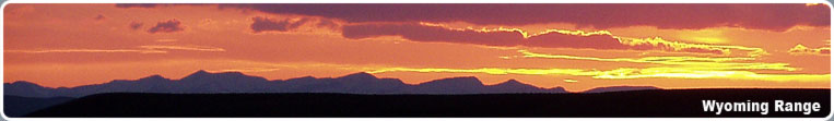
The Wyoming Mountain Range
Page Summary: Wyoming Mountain Range in western Wyoming. Attractions, outdoor activities, camping, destinations, and more.
 The Wyoming Mountain Range
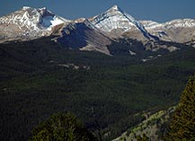
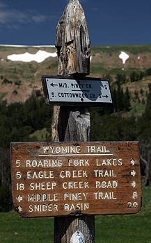
The Wyoming Range is not as rugged or remote as the nearby Wind River Range or Gros Ventre Mountains, but has a striking beauty all its own. The range runs for nearly eighty miles in a north-south direction in western Wyoming. The highest point is Wyoming Peak at 11,363 feet, and many of the peaks in the range rise to over 10,000 feet. Because these mountains are not as publicized as the Wind River Mountains, it is a great place to go to find solitude and an outdoor experience away from the crowds. Many backcountry hiking trails traverse these mountains, including the Wyoming Range National Recreation Trail. Trails are open to hikers, horseback riders and mountain bikers. Trails traverse remote, primitive country, and in some places trails may be hard to find. Roads usually are snow free from mid July until mid October. During the winter, roads serve as a network of snowmobile trails.
These mountains are home to elk, moose, deer, antelope, grizzly and black bear, mountain lions, lynx, and many other species of wildlife. The landscape is a mixture of rolling open slopes dotted with sagebrush and pockets of aspen trees and forested hills with coniferous forest. Rugged mountain peaks with stunning waterfalls plunging over high cliffs are tucked in the remote county.
There are many opportunities for dispersed camping throughout the Wyoming Range with scenic views and room to play. You'll need to bring your own water and answer calls of nature the primitive way at dispersed sites. There are also a number of developed campgrounds with restrooms and picnic tables in scenic locations.
Access to the range is by a network of one lane gravel roads that wind through the mountain slopes and are suitable for two wheel drive cars and trucks. Some roads are not recommended for RVs or trailers. Roads are often narrow and windy with limited sight distance, and caution is advised to watch for rocks on the road and wash boarded sections that can affect handing of your vehicle. To get to the interior, you need to park your car and either hike or go in on trails on horseback.
The Wyoming Range can be accessed from the west, east and north sides. Commercial services are available in the small towns on the perimeter, but none are available within the range. Get your gas and food in town, and be sure to have a full tank of gas and a good spare tire along. The towns of Daniel, Big Piney, Marbleton, LaBarge and Kemmerer are located on the east side of the mountains along US Highway 189. These are not large towns, but you'll be able to find gas, food and lodging (except for Daniel). On the northern end, Bondurant and Hoback Junction are along US Hwy 191. Again, these are small towns that have minimal services. On the west side of the range, services are available in Alpine, Thayne and Afton. Forest Service Ranger Station offices are located in Big Piney, Afton, and Jackson for more information.
Wyoming Range National Recreation Trail
This scenic trail system runs for approximately 70 miles along the Wyoming Range, with much of the trail at or near the crest above 9,000 feet elevation. Most of the trail is closed to motorized vehicles, although one short segment between Lake and North Piney creeks is open to trail bikes. The rest of the trail is for hikers, horseback riders and mountain bikers. Access is typically from July through September, although some portions may be accessed as early as mid-May or as late as mid-October, depending on the weather. Best time for optimum trail conditions and access is August and September. The trail begins in the north in the Hoback Canyon at Bryan Flat/Willow Creek at an elevation of 6,300 feet and ends at the South Piney Creek Trailhead at an elevation of 8,200 feet
Wyoming Range Snowmobiling Trails
Some of the world's most scenic snowmobiling goes on right here in Pinedale, Wyoming on hundreds of miles of groomed and ungroomed trails, and thousands of acres of off-trail riding. The Wyoming Range also offers an extensive system of logging roads for snowmobiling fun. These areas are less used by snowmobilers and offer a wide variety of terrain, from open sagebrush side hills to windy mountain roads through the forest. Horse Creek, North and South Cottonwood Creeks, Big Piney, Big Sandy or Cottonwood Creek areas for miles of open riding. Riders can explore snow-covered meadows, play on the hills along the way, and watch the wildlife!
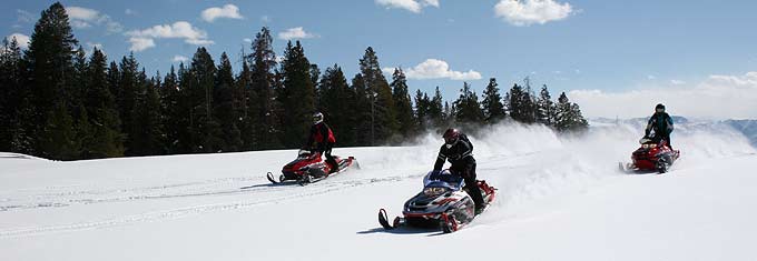
The Wyoming Range trails out of the east side of the Wyoming Range, less than 45 minutes from Pinedale, remains largely unknown providing minimal crowds, lots of off trail deep powder, hundreds of groomed and ungroomed trails, and unbelievable scenery.
Snowmobiling season typically runs from early December through mid April. January through mid-April is generally considered to be the best time. Temperatures at this time of year usually range from lows near zero to daytime highs in the mid twenties. Most days are sunny. The terrain is quite variable, ranging from flat to gently rolling sagebrush prairie to very rugged forested mountains. The elevation in Pinedale is 7,175 feet, but many trails are over 10,000 feet. Snowmobiles and equipment can be rented in town, and the local outfitters offer many different guided trips.
Snowmobiling trail maps are available at and the Sublette County Visitor's Center at 19 East Pine Street, by pre-trip free mail order (pre-trip) from the Wyoming State Trails Program website, or by free download. It is important for snowmobilers to refer to these maps for trail locations and restricted use areas. Restrictions vary by area and may not always be marked on the trail. Snowmobiling is not allowed within National Forest Wilderness Area boundaries.
Snowmobile Trail Conditions & Resources:
- Weekly Southwest Snowmobile Trail Conditions
- Local Snowmobile Experts: Bucky's Outdoors (307-367-4561, 146 S Lincoln, Pinedale, WY)
Wyoming Range Camping
Available Wyoming Range Campgrounds:
For More Information:
Big Piney Ranger District
Bridger-Teton National Forest
315 S Front St
Big Piney, WY 83113
307-276-3375Bridger-Teton National Forest
PO Box 1888
Jackson, WY 83001
307-739-5500