Gannett Peak - Tallest Mountain in WY
Page Summary: Gannett Peak, the highest peak in Wyoming, described here in detail. Facts, climbing, approach, camping, weather, & advice.
 Gannett Peak - Highest Peak in Wyoming at 13,804 feet
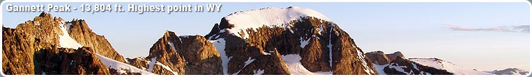
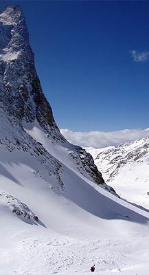
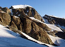
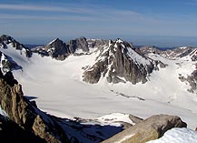
Gannett Peak is the highest peak in Wyoming, and in the Wind River Mountain Range, at 13,804 feet. It has five rugged glaciers on its flank, the largest glaciers in the American Rocky Mountains. It is remote and considered an exciting alpine mountaineering challenge due to its inaccessibility and moderate difficulty. The mountain was first climbed in 1922. This trip is best tackled by strong and experienced climbers with great stamina, well acclimated to high elevations. The trip includes traversing glaciers that contain deep crevasses that in early spring that can lay hidden under a coat of shallow snow. Ropes, crampons, ice axes and the knowledge on proper usage are essential. Furthermore, the strenuous 20+ mile trail hike approach adds to the endeavor. Over the past years, climbers report that the Goose Neck Route has changed dramatically. Due to receding and melting glaciers the route has become icier. The bergschrund is also becoming a more complex obstacle to overcome. It is recommended that groups attempting to climb this peak go earlier in the season, i.e. June and early July, so that snow bridges are in better condition.
Gannett Peak is located in the northern Wind River Mountain Range on the Continental Divide (in both the Fitzpatrick and Bridger Wilderness Areas), in west-central Wyoming (Fremont & Sublette Counties). It is 25 miles north-northeast of Pinedale. Looking at a map of the Wind River Mountains, locate Green River Lakes and New Fork Lakes north of Pinedale. Split the difference between the two lakes and go east approximately 10 air miles until you hit the Continental Divide and you'll see Gannett Peak.
Climbing Gannett Peak
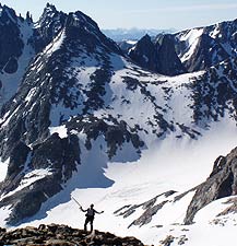
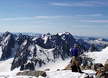
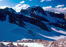
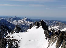
Gannett Peak is accessible from several routes. From Elkhart Park trailhead near Pinedale, the route of approach usually goes past Seneca and Island Lakes to the head of the Titcomb Basin. Depending on the overall length of the trip, training requirements, and whether horse packers have been used or not, it will take you 2 to 4 days to reach the upper Titcomb. Weather, conditioning, timing, and other variables determine the exact location of the summit camp. Summit day starts early so that you can reach the top in the morning hours and return to camp before dark. There are a number of route choices, the most popular one being the Gooseneck. All are technical and entail crossing glaciers, snow climbing and rock scrambling. Approaches from the Green River Lakes or New Fork Lake trailheads on the west side of the Wind River Range are longer than the traditional approach routes, but the rewards include being off the beaten path. Access to Gannett Peak is also popular from the Dubois side, with the Glacier Trail being the main and most popular trail, which starts outside the town of Dubois. Trail users should expect plenty of other company on the trail, including those on foot, horse pack strings, and those with llamas. It is recommended that visitors plan this for a multi-day trip, a couple days for travel in and out and a couple for exploring.
It is important to plan for several day's time to become well acclimated to the high elevation and for everyone in the party to be physically fit to handle the strenuous physical activity (3,000' vertical ascent) involved in this trip. Plan for at least a week for the long hike and ascent and for delays due to bad weather days. The mountain can be approached by several routes with varying degrees of difficulty, but none are easy. The approach is a long hike, over rocks, mud, snow and ice, fording freezing mountain snowmelt streams, balancing on logs may be necessary in order to transverse streams, and dealing with mosquitoes - and that's just to reach the base camp! Trails may not be well marked and are often rocky, dusty or muddy. Views are magnificent, and there are many opportunities to see wildlife (including the possibility of bear and moose visiting your camp). Be prepared for drastic, unexpected weather conditions. Summer days are typically warm, from the 70s to the 80s with afternoon thunderstorms. Check with the local Forest Service office before heading out to get current trail conditions and advisories for the area.
Typical conditions on Gannett Peak require a boot sturdy enough that strap-on crampons that can be worn for a few hours and heavy enough for snow climbing. Plastic double mountaineering boots are not suitable, they are too bulky and heavy on the approach. A mid-weight leather or kevlar boot is far better. Many people use an approach or running shoe for the trail hiking and also use it as their camp shoe. Functional rain pants and rain jacket are a necessity, keeping dry during wilderness mountaineering is crucial. High-tech rain gear made of breathable fabric is great but is often very expensive. Rain gear made of coated nylon will do the job for much less cost.
To make the trip more enjoyable, it is also recommended hiring porters or pack animals to haul gear. Guides and services are available in Pinedale, Jackson Hole and Dubois. Contact the Dubois and Pinedale Ranger District Forest Service offices for a list of legal licensed guides.
Camping near Gannett Peak
There are no suitable camping areas on the peak, so be prepared for a long day in and out (20-hour day) hiking the latter part of the trip on snow and glaciers. It is NOT recommended that parties camp on the glaciers, so suitable basecamps are approximately 3000' below the peak summit. Gannett is the longest round trip of any highpoint (including McKinley). The hike is at least 45 miles roundtrip and an almost 9,000 foot vertical climb. The best climbing months are July, August, early September. Trails may not always be well marked and are often rocky, dusty and muddy, but the views are worth the trip. Novices and newcomers are advised to hire guides to lead them through any trip. The glacier-clad 13,804' summit is many miles from the nearest road; climbing it is one of America's premier wilderness mountaineering trips.
Campsite locations are rather sparse near and in Titcomb Basin, and privacy is minimal due to the alpine nature of the setting. Because of the fragile landscape, visitors are asked to be sensitive to the environment and practice minimal impact camping techniques. Campers should also be "bear aware" and implement proper food storage methods to avoid attracting black bears, which are plentiful in the area. A four-footed bear visitor is most likely to visit your camp and prowl through your belongings at night. Bear-proof portable food storage containers are available for loan at the Pinedale Ranger District for a small fee. Contact the local Ranger District office or Wyoming Game and Fish Department to get the most recent report of bear activity prior to going into the backcountry for your trip.
Typical Weather Conditions
Summer days are typically warm and dry during the day, (70s-80s) with late-day thunderstorms with rain. Sub-freezing nighttime temperatures are not uncommon. Be prepared for high winds and rapidly changing weather conditions. Mountain snowstorms can occur any day of the year in the Rocky Mountains. Adequate clothing is a must, along with sunscreen, mosquito repellent, and water filtration equipment. Mosquitoes, deerflies and horseflies are plentiful most of the summer, making insect repellent a must. Bugs are usually gone by September. It is recommended hikers consider bringing a head net, tightly woven wind shells, and extra repellent if they do not wish to be bothered by bugs. Sleeping bags should be rated to -15 degrees. Be sure to bring lip balm, sunglasses with UV protection, insect repellent, warm socks & hat, gloves, rain gear, adequate shoes, water purification equipment, snack food, camera/film, and fishing gear!
Gannett Peak Advice
Keep in mind regulations for the Bridger Wilderness permit campfires only below timberline. Above timberline, campers must use gas stoves for cooking. The rule for refuse is "Pack out what you pack in". Do not bury garbage. What frost action does not bring garbage to the surface, animals will likely dig up and spread around. If you choose to bring your pet, you must be able to keep it under control, including barking, and away from other camps and hikers. Pets should be kept on a leash if you cannot keep it from chasing wildlife, and they must be properly vaccinated and have ID tags in case they get lost.
Be aware that this is very remote country, and potential dangers are part of the wilderness experience. You must be prepared to take care of yourself in case of an accident. Help is a long ways away, and you cannot count on your cell phone being able to have reception out to call for help. It is wise to ravel with at least one other person and log a travel plan with a friend on where you are going and when you will return. Know basic first aid and carry a first aid kit. The most common dangers in the high reaches of the Bridger Wilderness are high altitude sickness, hypothermia, and dehydration.
Comments from other Gannett Peak Climbers
"It was the most difficult and most rewarding climbing experience I have ever had."
"This was one of the greatest experiences of my life. There is nothing to explain the feeling of being on the summit of a peak as great as Gannett."
"This peak is all about conditioning. Without it forget it. There aren't any real hard technical moves, but it has a little bit of everything to keep you interested."
"It still remains one of the highlights of my outdoor experiences! The vistas are really beautiful - some of the best in the lower 48!"
"Be careful. Dead is dead"
"This mountain had it all: A long approach, glacial travel, technical rock climbing, and perhaps the most beautiful scenery in the lower 48. A favorite!"
"Main advice: Get in shape, acclimate."
For More Information
Pinedale Ranger District
Bridger-Teton National Forest
PO Box 220
29 East Fremont Lake Road
Pinedale, WY 82941
(307) 367-4326
http://www.fs.usda.gov/btnf/